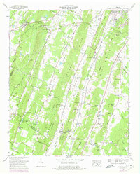
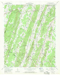
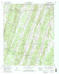
1967 Map of Mc Donald
USGS Topo · Published 1977About this map
McDonald sits as a primary junction in the northwest corner of this Bradley County landscape, where the Southern Railway runs parallel to the Lee Highway. This 1967 survey reveals a deeply patterned rural economy defined by ridges and valley roads, including the Old Alabama Road and Apison Pike. The terrain is dominated by a series of parallel elevations such as White Oak Ridge and Lebanon Ridge, which channel the flow of Candies Creek and Black Fox Creek.
Find a feature on this map
90 named features on this map. Tap any name to fly to it.
Don’t see what you’re looking for? This feature index may not catch every label — zoom into the map to look around manually.
Map Details
Editions of this 1967 Mc Donald Map
3 editions found
Other maps of this area

1886 · Dalton
USGS Topo · 1:125,000

1886 · Cleveland
USGS Topo · 1:125,000

1886 · Ringgold
USGS Topo · 1:125,000

1888 · Chattanooga
USGS Topo · 1:125,000

1892 · Ringgold
USGS Topo · 1:125,000

1892 · Cleveland
USGS Topo · 1:125,000

1892 · Dalton
USGS Topo · 1:125,000

1893 · Chattanooga
USGS Topo · 1:125,000

1895 · Cleveland
USGS Topo · 1:125,000

1897 · Dalton
USGS Topo · 1:125,000