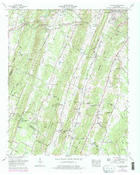
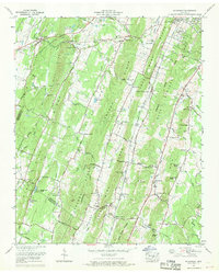
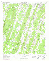
1967 Map of Mc Donald
USGS Topo · Published 1977About this map
McDonald serves as the primary community along the Southern Railway in this corner of the Tennessee Valley, where the topography is defined by parallel ridges like White Oak Ridge and Lebanon Ridge. The landscape reflects a mid-century rural economy shifting between agriculture and early infrastructure developments, evidenced by numerous silos and a substation. Local genealogy is well-documented through scattered landmarks such as Corinth Ch, Lee Cem, and the McDonald Sch. Historical transit corridors are particularly visible, including the Old Alabama Road and the distinctive railway stops at Marble Switch and Weatherly Switch. To the south, the county line between Bradley and Hamilton counties cuts across the valley floor near Hidden Valley Camp and Taylor Spring, while the heights of Red Hill are anchored by the Red Hill Lookout Tower.
Find a feature on this map
100 named features on this map. Tap any name to fly to it.
Don’t see what you’re looking for? This feature index may not catch every label — zoom into the map to look around manually.
Map Details
Editions of this 1967 Mc Donald Map
3 editions found
Other maps of this area

1886 · Dalton
USGS Topo · 1:125,000

1886 · Cleveland
USGS Topo · 1:125,000

1886 · Ringgold
USGS Topo · 1:125,000

1888 · Chattanooga
USGS Topo · 1:125,000

1892 · Ringgold
USGS Topo · 1:125,000

1892 · Cleveland
USGS Topo · 1:125,000

1892 · Dalton
USGS Topo · 1:125,000

1893 · Chattanooga
USGS Topo · 1:125,000

1895 · Cleveland
USGS Topo · 1:125,000

1897 · Dalton
USGS Topo · 1:125,000