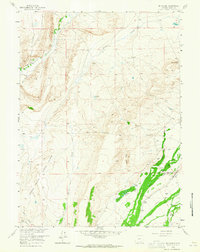
1958 Map of Mc Fadden
USGS Topo · Published 1965About this map
McFadden stands as the primary hub of activity in this 1950s study of Carbon County, where the petroleum industry and cattle ranching shape the landscape. The Rock Creek Oil Field is a dominant feature, characterized by numerous oil wells and a central Refinery, indicating the area's economic engine during the mid-20th century. This industrial footprint contrasts with the surrounding agricultural operations, marked by established family-named properties such as Sims Ranch, Mc Quay Ranch, and White Ranch.
Find a feature on this map
25 named features on this map. Tap any name to fly to it.
Don’t see what you’re looking for? This feature index may not catch every label — zoom into the map to look around manually.
Map Details
Editions of this 1958 Mc Fadden Map
3 editions found
Other maps of this area

1914 · Saddleback Hills
USGS Topo · 1:62,500

1915 · Como Ridge
USGS Topo · 1:48,000

1918 · Como Ridge
USGS Topo · 1:62,500

1921 · Saddleback Hills
USGS Topo · 1:62,500

1954 · Rawlins
USGS Topo · 1:250,000

1958 · Rawlins
USGS Topo · 1:250,000

1958 · White Rock Canyon
USGS Topo · 1:24,000

1958 · Bengough Hill
USGS Topo · 1:24,000

1958 · Arlington
USGS Topo · 1:24,000

1958 · Mc Fadden
USGS Topo · 1:24,000