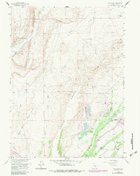
1958 Map of Mc Fadden
USGS Topo · Published 1983About this map
The Rock Creek Oil Field dominates the southeastern quadrant of this Carbon County landscape, showcasing the infrastructure of Wyoming's mid-century energy production. Industrial features including a Refinery, numerous Oil Wells, and a network of pipelines are interspersed with historic agricultural holdings like the Sims Ranch, White Ranch, and Le Beau Ranch. The high-plains terrain is further defined by the Overland Trail, which cuts across the southwestern corner, marking the path of early westward migration.
Find a feature on this map
36 named features on this map. Tap any name to fly to it.
Don’t see what you’re looking for? This feature index may not catch every label — zoom into the map to look around manually.
Map Details
Editions of this 1958 Mc Fadden Map
3 editions found
Other maps of this area

1914 · Saddleback Hills
USGS Topo · 1:62,500

1915 · Como Ridge
USGS Topo · 1:48,000

1918 · Como Ridge
USGS Topo · 1:62,500

1921 · Saddleback Hills
USGS Topo · 1:62,500

1954 · Rawlins
USGS Topo · 1:250,000

1958 · Rawlins
USGS Topo · 1:250,000

1958 · White Rock Canyon
USGS Topo · 1:24,000

1958 · Bengough Hill
USGS Topo · 1:24,000

1958 · Arlington
USGS Topo · 1:24,000

1958 · Mc Fadden
USGS Topo · 1:24,000