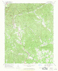
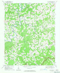
1968 Map of Mc Grady
USGS Topo · Published 1971About this map
McGrady and Halls Mills anchor this mountainous landscape in Wilkes County during the late 1960s, a region defined by the complex drainage systems of the Mulberry River and the Roaring River. The topography is dominated by massive ridges including Blue Ridge and Chestnut Mountain, while much of the northern terrain is preserved within the Thurmond Chatham Wildlife Management Area. The map reveals a deeply established rural community, tracing the winding paths of Long Bottom Road and Radical Road.
Find a feature on this map
79 named features on this map. Tap any name to fly to it.
Don’t see what you’re looking for? This feature index may not catch every label — zoom into the map to look around manually.
Map Details
Editions of this 1968 Mc Grady Map
2 editions found
Other maps of this area

1889 · Wilkesboro
USGS Topo · 1:125,000

1891 · Wilkesboro
USGS Topo · 1:125,000

1953 · Winston-Salem
USGS Topo · 1:250,000

1955 · Winston-Salem
USGS Topo · 1:250,000

1962 · Winston-Salem
USGS Topo · 1:250,000

1966 · Roaring River
USGS Topo · 1:24,000

1966 · Wilkesboro
USGS Topo · 1:24,000
1966 · Purlear
USGS Topo · 1:24,000
1968 · Glade Valley
USGS Topo · 1:24,000
1968 · Laurel Springs
USGS Topo · 1:24,000