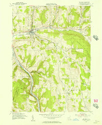
1955 Map of Mc Graw
USGS Topo · Published 1956About this map
McGraw and the surrounding agricultural uplands are defined by the winding course of Trout Brook and the steep valleys of the Tioughnioga River in this mid-century survey. The landscape reflects a legacy of early industry and settlement, with small hubs like Maybury Mills and Blodgett Mills positioned near water sources and transportation corridors. The Delaware Lackawanna and Western RR cuts through the terrain, tracing the natural contours of the valley floors to connect these rural townships.
Find a feature on this map
30 named features on this map. Tap any name to fly to it.
Don’t see what you’re looking for? This feature index may not catch every label — zoom into the map to look around manually.
Map Details
Editions of this 1955 Mc Graw Map
4 editions found
Other maps of this area

1903 · Cortland
USGS Topo · 1:62,500

1903 · Harford
USGS Topo · 1:62,500

1904 · Greene
USGS Topo · 1:62,500

1904 · Pitcher
USGS Topo · 1:62,500

1906 · Catatonk
USGS Topo · 1:125,000

1943 · Cincinnatus
USGS Topo · 1:24,000

1943 · Cuyler
USGS Topo · 1:24,000
1944 · Homer
USGS Topo · 1:31,680

1944 · Cortland
USGS Topo · 1:31,680
1944 · Cuyler
USGS Topo · 1:31,680