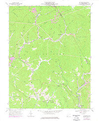
1967 Map of Mc Graws
USGS Topo · Published 1977About this map
Coal and timber interests define the landscape of Wyoming County in the late 1960s, where the Norfolk and Western railway threads through the narrow valleys of Slab Fork and Marsh Fork. The community of Glen Rogers stands as a primary hub, complete with its Glen Rogers High Sch and industrial infrastructure like a large substation and mine dumps. This era shows a transition in land use, as the northern portion of Twin Falls State Park appears alongside active extractive operations, including various strip mines and a mine tipple. The rugged terrain is punctuated by significant gaps such as Skinned Poplar Gap and Wolf Gap, which dictated the placement of early mountain roads. For genealogists, the map preserves the locations of several rural congregations, including Pinegrove Ch and Friendship Ch, as well as numerous family-named landmarks like Wallis Branch and Oliver Branch.
Find a feature on this map
69 named features on this map. Tap any name to fly to it.
Don’t see what you’re looking for? This feature index may not catch every label — zoom into the map to look around manually.
Map Details
Editions of this 1967 Mc Graws Map
2 editions found
Other maps of this area

1891 · Oceana
USGS Topo · 1:125,000

1891 · Raleigh
USGS Topo · 1:125,000

1893 · Oceana
USGS Topo · 1:125,000

1897 · Raleigh
USGS Topo · 1:125,000

1898 · Oceana
USGS Topo · 1:125,000

1902 · Raleigh
USGS Topo · 1:125,000

1910 · Pineville
USGS Topo · 1:48,000

1910 · Bald Knob
USGS Topo · 1:48,000

1911 · Marshes
USGS Topo · 1:48,000

1912 · Mullens
USGS Topo · 1:62,500