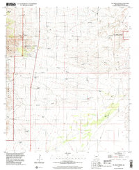
1996 Map of Mc Grew Spring
USGS Topo · Published 2002About this map
Kartchner Caverns State Park anchors this desert landscape in Cochise County, where the Whetstone Mountains meet the San Pedro River valley. The terrain is defined by a series of dramatic drainages including Guindani Canyon, Middle Canyon, and Dry Canyon, which fall away from the national forest boundary toward the eastern lowlands. Human activity is marked by scattered ranching and mining infrastructure, with sites like the Ricketts Mine and H & D Mine appearing alongside numerous water catchments like Mesquite Tank and Bates Tank. The map captures a transition in land management at the close of the 20th century, showing the established Coronado National Forest alongside the San Pedro Riparian National Conservation Area and the municipal Benson Corporate Boundary creeping in from the north.
Find a feature on this map
37 named features on this map. Tap any name to fly to it.
Don’t see what you’re looking for? This feature index may not catch every label — zoom into the map to look around manually.
Map Details
Editions of this 1996 Mc Grew Spring Map
This is the sole edition of this map. No revisions or reprints were ever made.
Other maps of this area

1915 · Benson
USGS Topo · 1:125,000

1922 · St. David
USGS Topo · 1:62,500

1926 · Whetstone
USGS Topo · 1:62,500

1932 · Fairbank
USGS Topo · 1:62,500

1938 · Huachuca
USGS Topo · 1:62,500

1943 · Benson
USGS Topo · 1:125,000

1948 · Fort Huachuca NE
USGS Topo · 1:24,000
1948 · Mustang Mountains
USGS Topo · 1:24,000
1948 · Fort Huachuca
USGS Topo · 1:62,500
1952 · Fairbank
USGS Topo · 1:24,000