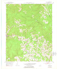
1953 Map of Mc Kee
USGS Topo · Published 1978About this map
The Cumberland National Forest dominates this Jackson County landscape, where the deeply dissected plateau creates a complex network of hollows and ridges. Centered on the community of Mc Kee, the map reveals a mid-century rural economy defined by scattered settlements and natural resource extraction. Small mining operations like Gray Hawk and a Strip Mine are nestled among the drainages of War Fork and Middle Fork. These watercourses dictate the placement of local infrastructure, with winding roads following the contours to reach remote outposts such as New Zion, Atkinstown, and Privett.
Find a feature on this map
55 named features on this map. Tap any name to fly to it.
Don’t see what you’re looking for? This feature index may not catch every label — zoom into the map to look around manually.
Map Details
Editions of this 1953 Mc Kee Map
3 editions found
Other maps of this area

1891 · Manchester
USGS Topo · 1:125,000

1892 · Richmond
USGS Topo · 1:125,000

1892 · Beattyville
USGS Topo · 1:125,000

1893 · London
USGS Topo · 1:125,000

1897 · Richmond
USGS Topo · 1:125,000

1897 · London
USGS Topo · 1:125,000

1952 · Alcorn
USGS Topo · 1:24,000

1952 · Leighton
USGS Topo · 1:24,000

1952 · Heidelberg
USGS Topo · 1:24,000

1953 · Mc Kee
USGS Topo · 1:24,000