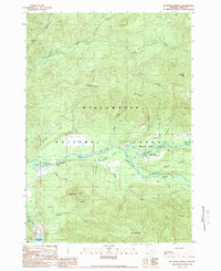
1989 Map of Mc Kenzie Bridge
USGS Topo · Published 1989About this map
Mc Kenzie River white water and dense timberlands define this 1989 portrait of the Willamette National Forest. Centered on the settlement of McKenzie Bridge, the map reveals a landscape managed for both utility and recreation, where Cougar Dam regulates the Cougar Reservoir and a high-voltage Transmission Line cuts through the forest south of Rainbow. The presence of the Mc Kenzie Covered Bridge and another Covered Bridge on Horse Creek highlights the local engineering heritage of Lane County.
Find a feature on this map
42 named features on this map. Tap any name to fly to it.
Don’t see what you’re looking for? This feature index may not catch every label — zoom into the map to look around manually.
Map Details
Editions of this 1989 Mc Kenzie Bridge Map
This is the sole edition of this map. No revisions or reprints were ever made.
Other maps of this area

1934 · Mc Kenzie Bridge
USGS Topo · 1:96,000

1940 · Mc Kenzie Bridge
USGS Topo · 1:125,000

1953 · Salem
USGS Topo · 1:250,000

1954 · Salem
USGS Topo · 1:250,000

1955 · Blue River
USGS Topo · 1:62,500

1955 · Cascadia
USGS Topo · 1:62,500

1955 · Echo Mountain
USGS Topo · 1:62,500

1955 · Mc Kenzie Bridge
USGS Topo · 1:62,500

1960 · Salem
USGS Topo · 1:250,000

1962 · Salem
USGS Topo · 1:250,000