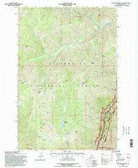
1994 Map of Mc Lendon Butte
USGS Topo · Published 1998About this map
Lochsa Canyon dominates the southeastern quadrant of this terrain, where the Lochsa River carves through the landscape of the Clearwater National Forest. This 1994 revision, based on earlier aerial photography, captures the intricate boundary between national forest lands and the Selway-Bitterroot Wilderness. The map reveals a network of high-elevation points such as Mc Lendon Butte, Fish Butte, and Smoky Peak, interspersed with remote outposts like Obia Cabin. Significant water features including Hungery Creek and Bimerick Creek drain the steep slopes, leading toward the river. The presence of Bimerick Meadows and named landmarks like Ant Hill and Willow Ridge provide specific navigational points for those studying the land use and natural history of this portion of Idaho County during the late twentieth century.
Find a feature on this map
32 named features on this map. Tap any name to fly to it.
Don’t see what you’re looking for? This feature index may not catch every label — zoom into the map to look around manually.
Map Details
Editions of this 1994 Mc Lendon Butte Map
This is the sole edition of this map. No revisions or reprints were ever made.
Other maps of this area

1911 · Lolo
USGS Topo · 1:250,000

1913 · Lolo
USGS Topo · 1:250,000

1924 · Weippe
USGS Topo · 1:125,000

1956 · Hamilton
USGS Topo · 1:250,000

1959 · Hamilton
USGS Topo · 1:250,000

1960 · Hamilton
USGS Topo · 1:250,000

1964 · Hamilton
USGS Topo · 1:250,000

1966 · Lowell
USGS Topo · 1:24,000
1966 · Snowy Summit
USGS Topo · 1:24,000
1966 · Coolwater Mtn
USGS Topo · 1:24,000