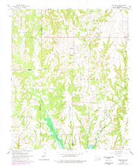
1963 Map of Mc Millan
USGS Topo · Published 1978About this map
McMillan serves as a central landmark in this Marshall County landscape, where rural life is defined by the winding drainages of Wilson Creek and Little Hauani Creek. The area’s settlement history is evident in the presence of the McMillan Cem and nearby Pickens Ch, while the southern reaches of the map show the significant impact of Lake Texoma as it fills the lower valleys. This 1963 survey, photorevised in 1976, captures a transition from traditional agricultural land use to more industrial activity, as evidenced by the numerous Gravel Pits and a Quarry scattered along the eastern ridges. The complex boundary lines of Carter, Love, and Marshall Counties intersect here, illustrating the jurisdictional patchwork of this Oklahoma interior as it appeared before further modern development.
Find a feature on this map
18 named features on this map. Tap any name to fly to it.
Don’t see what you’re looking for? This feature index may not catch every label — zoom into the map to look around manually.
Map Details
Editions of this 1963 Mc Millan Map
2 editions found

Other maps of this area

1901 · Tishomingo
USGS Topo · 1:125,000

1901 · Ardmore
USGS Topo · 1:125,000

1901 · Denison
USGS Topo · 1:125,000

1902 · Gainesville
USGS Topo · 1:125,000

1918 · Ardmore
USGS Topo · 1:125,000

1943 · Gainesville
USGS Topo · 1:125,000

1954 · Sherman
USGS Topo · 1:250,000

1957 · Ardmore
USGS Topo · 1:250,000

1958 · Gordonville
USGS Topo · 1:62,500

1958 · Sherman
USGS Topo · 1:250,000