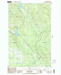
1985 Map of Mc Murray
USGS Topo · Published 1985About this map
Mc Murray sits at the southwestern shore of Lake McMurray, serving as a central point of settlement in this 1980s landscape bridging Skagit and Snohomish counties. The geography is defined by a dense network of water bodies, from the sprawling Big Lake in the northwest to smaller, isolated features like Devils Lake and Seabury Pond. A significant industrial and transport legacy is visible in the prominent Old Railroad Grade that winds through the valley floor alongside Creek and Pilchuck Creek, indicating the historical movement of timber or minerals from nearby sites like the Quarry in Walker Valley. This survey captures the region just as modern infrastructure, such as the Pipeline and Transmission Line, began to overlay the older resource-extraction routes, while the Pilchuck Bridge Campground points toward the area's increasing role in local recreation.
Find a feature on this map
18 named features on this map. Tap any name to fly to it.
Don’t see what you’re looking for? This feature index may not catch every label — zoom into the map to look around manually.
Map Details
Editions of this 1985 Mc Murray Map
This is the sole edition of this map. No revisions or reprints were ever made.
Other maps of this area

1911 · Mount Vernon
USGS Topo · 1:125,000

1940 · Mt Vernon
USGS Topo · 1:62,500

1941 · Marysville
USGS Topo · 1:62,500

1943 · Marysville
USGS Topo · 1:62,500

1943 · Mt Vernon
USGS Topo · 1:62,500

1943 · Stanwood
USGS Topo · 1:62,500

1944 · Clear Lake
USGS Topo · 1:62,500

1956 · Arlington West
USGS Topo · 1:24,000

1956 · Arlington East
USGS Topo · 1:24,000
1956 · Stanwood
USGS Topo · 1:24,000