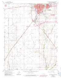
1965 Map of Mc Pherson South
USGS Topo · Published 1985About this map
McPherson serves as a bustling rail and educational hub in the mid-1960s, defined by the crossroads of the St Louis Southwestern and Missouri Pacific railroads. The town's character is shaped by institutions like McPherson College and Central College, while its industrial profile is anchored by a large Refinery and the nearby McPherson Airport. Surrounding the urban center, the landscape transitions into the agricultural reaches of King City and Groveland townships.
Find a feature on this map
35 named features on this map. Tap any name to fly to it.
Don’t see what you’re looking for? This feature index may not catch every label — zoom into the map to look around manually.
Map Details
Editions of this 1965 Mc Pherson South Map
3 editions found
Other maps of this area

1891 · Hutchinson
USGS Topo · 1:125,000

1893 · Hutchinson
USGS Topo · 1:125,000

1955 · Hutchinson
USGS Topo · 1:250,000

1959 · Hutchinson
USGS Topo · 1:250,000

1964 · Conway
USGS Topo · 1:24,000

1965 · Mc Pherson South
USGS Topo · 1:24,000

1965 · Galva
USGS Topo · 1:24,000

1965 · Halstead NW
USGS Topo · 1:24,000
1965 · Mc Pherson SE
USGS Topo · 1:24,000
1965 · Mc Pherson North
USGS Topo · 1:24,000