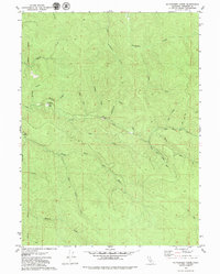
1979 Map of Mc Whinney Creek
USGS Topo · Published 1979About this map
The timbered drainage basins of the Freshwater Creek and North Fork Elk River dominate this 1970s landscape in Humboldt County. Evidence of the region’s industrial past is anchored by the Falk (Ruins), once a significant company lumber town, located near the McCloud Creek confluence. The terrain is a complex network of steep gulches and creek forks, including Browns Gulch and Dunlap Gulch, which have historically facilitated the movement of redwood timber from the hills.
Find a feature on this map
26 named features on this map. Tap any name to fly to it.
Don’t see what you’re looking for? This feature index may not catch every label — zoom into the map to look around manually.
Map Details
Editions of this 1979 Mc Whinney Creek Map
2 editions found
Other maps of this area

1922 · Eureka
USGS Topo · 1:62,500

1922 · Korbel
USGS Topo · 1:62,500

1922 · Kneeland
USGS Topo · 1:62,500

1933 · Eureka
USGS Topo · 1:48,000

1942 · Eureka
USGS Topo · 1:62,500

1944 · Fortuna
USGS Topo · 1:62,500

1945 · Blue Lake
USGS Topo · 1:62,500

1949 · Eureka
USGS Topo · 1:250,000

1950 · Iaqua Buttes
USGS Topo · 1:62,500

1951 · Eureka
USGS Topo · 1:62,500