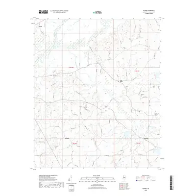
2018 Map of McAfee
USGS Topo · Published 2018About this map
Lobutcha Creek and the Pearl River form a low-lying basin in this rural section of Leake County, where the landscape is defined by its small, long-established farming communities. The settlement of Standing Pine sits near the center of the sheet, surrounded by historic family and community landmarks such as Hopewell Cem and Standing Pine Cem. The transport network of the late 2010s relies on traditional routes like Collier Ferry Rd, which points to the area's history of river crossings.
Find a feature on this map
79 named features on this map. Tap any name to fly to it.
Don’t see what you’re looking for? This feature index may not catch every label — zoom into the map to look around manually.
Map Details
Editions of this 2018 McAfee Map
This is the sole edition of this map. No revisions or reprints were ever made.
Other maps of this area

1953 · Meridian
USGS Topo · 1:250,000

1957 · Meridian
USGS Topo · 1:250,000

1961 · Carthage
USGS Topo · 1:62,500

1962 · Edinburg
USGS Topo · 1:62,500

1962 · Thomastown
USGS Topo · 1:62,500

1965 · Meridian
USGS Topo · 1:250,000

1972 · McAfee
USGS Topo · 1:24,000

1972 · Madden
USGS Topo · 1:24,000
1972 · Sebastopol
USGS Topo · 1:24,000
1972 · Walnut Grove
USGS Topo · 1:24,000