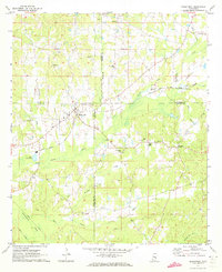
1972 Map of Sebastopol
USGS Topo · Published 1973About this map
Sebastopol sits at the nexus of four Mississippi counties, where the Gulf Mobile and Ohio railroad corridor serves as a primary axis for the region's mid-century landscape. The area is defined by a dense network of country churches and small community centers like Salem and Kitchener, reflecting the rural social fabric of the early 1970s. Waterways like Bogue Faliah, Sipsey Creek, and Tuscolameta Creek wind through the terrain, with local landmarks such as Steam Mill and Substation indicating localized industrial and utility points. Geographers and historians will note the complex boundary lines where Scott, Leake, Neshoba, and Newton counties meet, as well as the artificial North Canal and South Canal projects that redirected local drainage. The map provides a clear look at local spiritual life through numerous sites like High Hill Ch, Reids Chapel, and White Plains Ch.
Find a feature on this map
36 named features on this map. Tap any name to fly to it.
Don’t see what you’re looking for? This feature index may not catch every label — zoom into the map to look around manually.
Map Details
Editions of this 1972 Sebastopol Map
This is the sole edition of this map. No revisions or reprints were ever made.
Other maps of this area

1921 · Forest
USGS Topo · 1:48,000

1922 · Forest
USGS Topo · 1:62,500

1950 · Forest
USGS Topo · 1:62,500

1952 · Forest
USGS Topo · 1:62,500

1953 · Meridian
USGS Topo · 1:250,000

1957 · Meridian
USGS Topo · 1:250,000

1965 · Meridian
USGS Topo · 1:250,000

1966 · Decatur NW
USGS Topo · 1:24,000

1972 · McAfee
USGS Topo · 1:24,000

1972 · Madden
USGS Topo · 1:24,000