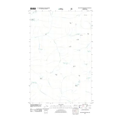
2011 Map of McAlester Mountain
USGS Topo · Published 2011About this map
McAlester Mountain dominates this high-altitude landscape in the North Cascades, defined by a complex network of glacial drainage and alpine passes. The map documents a primitive backcountry environment where Fireweed Camp serves as a lone named outpost along Bridge Creek. These waterways, including McAlester Creek and the North Fork Twisp River, flow through deep basins carved by ice, with the Lyall Glacier remaining a prominent feature in the northwest corner. This 2011 survey captures the hydrological relationships between alpine tarns like McAlester Lake, Dagger Lake, and Kettling Lake. The geography is anchored by significant transit points like Twisp Pass and McAlester Pass, which have historically provided the only passage through this vertical terrain. The drainage patterns of Solleks Creek and Rainbow Creek reveal the steep gradients that isolate the massive Rainbow Ridge from surrounding peaks.
Find a feature on this map
37 named features on this map. Tap any name to fly to it.
Don’t see what you’re looking for? This feature index may not catch every label — zoom into the map to look around manually.
Map Details
Editions of this 2011 McAlester Mountain Map
This is the sole edition of this map. No revisions or reprints were ever made.
Other maps of this area

1902 · Stehekin
USGS Topo · 1:125,000

1904 · Stehekin
USGS Topo · 1:125,000

1920 · Slate Pass
USGS Topo · 1:125,000

1955 · Concrete
USGS Topo · 1:250,000

1958 · Concrete
USGS Topo · 1:250,000

1962 · Concrete
USGS Topo · 1:250,000

1963 · Washington Pass
USGS Topo · 1:24,000

1963 · Mc Gregor Mtn
USGS Topo · 1:24,000
1963 · Mt. Arriva
USGS Topo · 1:24,000

1963 · Silver Star Mtn.
USGS Topo · 1:24,000