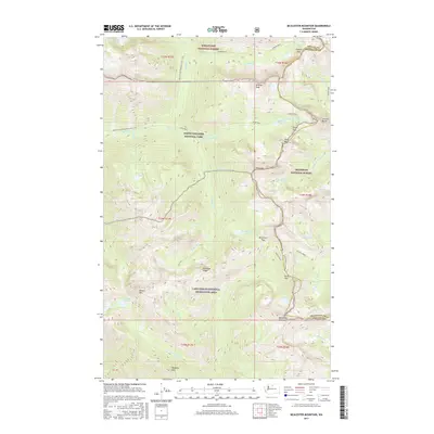
2017 Map of McAlester Mountain
USGS Topo · Published 2017About this map
McAlester Mountain and the high alpine drainage of the S Fork Twisp River anchor this topographic study of the Chelan and Okanogan county lines. The landscape is defined by its transition between four major federal land designations, including North Cascades National Park and the Lake Chelan National Recreation Area. The Pacific Crest National Scenic Trail winds through the northwestern corner, following the terrain near Rainy Lake and providing a glimpse into the established corridor of the mid-2010s. This survey documents a critical network of mountain passes, from Copper Pass in the north down to South Pass and McAlester Pass, which have historically facilitated movement across these high ridges. Glacial lakes like Twisp Lake, Dagger Lake, and McAlester Lake are scattered among the peaks, including Stiletto Peak and Bowan Mtn, marking the headwaters for numerous creeks that feed into the larger regional watersheds.
Find a feature on this map
49 named features on this map. Tap any name to fly to it.
Don’t see what you’re looking for? This feature index may not catch every label — zoom into the map to look around manually.
Map Details
Editions of this 2017 McAlester Mountain Map
This is the sole edition of this map. No revisions or reprints were ever made.
Other maps of this area

1902 · Stehekin
USGS Topo · 1:125,000

1904 · Stehekin
USGS Topo · 1:125,000

1920 · Slate Pass
USGS Topo · 1:125,000

1955 · Concrete
USGS Topo · 1:250,000

1958 · Concrete
USGS Topo · 1:250,000

1962 · Concrete
USGS Topo · 1:250,000

1963 · Washington Pass
USGS Topo · 1:24,000

1963 · Mc Gregor Mtn
USGS Topo · 1:24,000
1963 · Mt. Arriva
USGS Topo · 1:24,000

1963 · Silver Star Mtn.
USGS Topo · 1:24,000