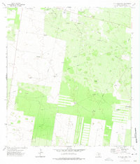
1972 Map of McAllen Ranch
USGS Topo · Published 1975About this map
The Mc Allen Ranch area of Hidalgo County is defined by a dense network of water infrastructure and energy extraction essential to this arid South Texas landscape. In the early 1970s, the terrain was heavily marked by the Oil and Gas Field and a labyrinth of pipelines feeding into a central Gas Plant and Pumping Station. Ranching operations are evidenced by a series of named windmills—including Los Indios Windmill, Santa Maria Windmill, and San Ignacio Windmill—which provided the critical water supply for livestock and settlement. Genealogy researchers will find the Guadalupe Toreros Cem in the northwest, while the presence of the Landing Strip near the ranch headquarters underscores the industrial and logistical requirements of managing such a remote and specialized operation. The map also records unique hydrological features like the Santa Monica Well (Flowing), suggesting the subsurface pressures of the region during this era.
Find a feature on this map
26 named features on this map. Tap any name to fly to it.
Don’t see what you’re looking for? This feature index may not catch every label — zoom into the map to look around manually.
Map Details
Editions of this 1972 McAllen Ranch Map
2 editions found
Other maps of this area

1939 · Linn
USGS Topo · 1:62,500

1939 · La Reforma
USGS Topo · 1:62,500

1940 · Monte Christo
USGS Topo · 1:62,500

1949 · Mc Allen
USGS Topo · 1:250,000

1954 · McAllen
USGS Topo · 1:250,000

1957 · Mc Allen
USGS Topo · 1:250,000

1962 · McAllen
USGS Topo · 1:250,000

1963 · Monte Christo
USGS Topo · 1:24,000

1963 · Linn NW
USGS Topo · 1:24,000
1963 · Faysvillle
USGS Topo · 1:24,000