
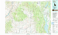
1980 Map of McCall
USGS Topo · Published 1993About this map
Long Valley and the surrounding timberlands of the Payette National Forest anchor this 1980 survey, illustrating a landscape defined by water and wood. The drainage of the North Fork Payette River feeds into Payette Lake and the significant Cascade Reservoir to the south, while the Union Pacific railroad tracks follow the corridor of the Weiser River. Small agricultural and timber-linked settlements like Roseberry, Donnelly, and Fruitvale are scattered along the valley floors, providing a look at the rural infrastructure before late-century development intensified.
Find a feature on this map
81 named features on this map. Tap any name to fly to it.
Don’t see what you’re looking for? This feature index may not catch every label — zoom into the map to look around manually.
Map Details
Editions of this 1980 McCall Map
2 editions found
Other maps of this area

1894 · Squaw Creek
USGS Topo · 1:125,000

1897 · Weiser
USGS Topo · 1:125,000

1909 · Garden Valley
USGS Topo · 1:125,000

1911 · Meadows
USGS Topo · 1:125,000

1915 · Pine
USGS Topo · 1:125,000

1920 · Seven Devils Mining District
USGS Topo · 1:48,000

1938 · Riggins
USGS Topo · 1:96,000

1945 · Riggins
USGS Topo · 1:125,000

1952 · Olds Ferry
USGS Topo · 1:62,500

1953 · Smiths Ferry
USGS Topo · 1:62,500