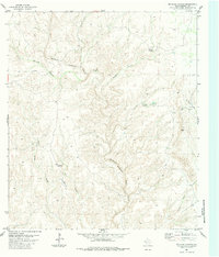
1983 Map of McClain Canyon
USGS Topo · Published 1984About this map
Sanderson Creek winds through this arid expanse of Terrell County, cutting through a series of canyons including Seminole Canyon and McClain Canyon. The map illustrates a landscape defined by limited water sources and isolated ranching outposts, such as the Gatlin Ranch and Harrison Ranch. These homesteads are supported by essential features like Springs, Lake Tank, and the unique Indian Pothole, reflecting the challenges of life in this part of the Trans-Pecos. A solitary Landing Strip near Lion Canyon serves as a reminder of the vast distances between settlements in West Texas during the late twentieth century. To the southeast, the drainage of Garcia Creek and Persimmon Creek further shapes the terrain, providing a look at the hydrography of the region before modern developments.
Find a feature on this map
13 named features on this map. Tap any name to fly to it.
Don’t see what you’re looking for? This feature index may not catch every label — zoom into the map to look around manually.
Map Details
Editions of this 1983 McClain Canyon Map
This is the sole edition of this map. No revisions or reprints were ever made.
Other maps of this area

1918 · Dryden Crossing
USGS Topo · 1:62,500

1918 · Indian Wells
USGS Topo · 1:62,500

1928 · Sanderson
USGS Topo · 1:125,000

1954 · Fort Stockton
USGS Topo · 1:250,000

1958 · Fort Stockton
USGS Topo · 1:250,000

1959 · Emory Peak
USGS Topo · 1:250,000

1965 · Emory Peak
USGS Topo · 1:250,000

1968 · Dryden
USGS Topo · 1:24,000

1969 · Sanderson SE
USGS Topo · 1:24,000

1969 · Mofeta
USGS Topo · 1:24,000