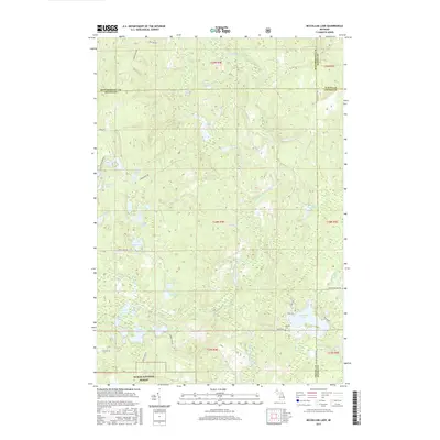
2017 Map of McCollum Lake
USGS Topo · Published 2017About this map
The Upper S Br Thunder Bay River and its numerous glacial kettle lakes define this northern Michigan landscape at the intersection of Alpena, Alcona, Montmorency, and Oscoda Counties. Large portions of the terrain fall within the Huron National Forest, where a network of forest roads like Saddleback Lake Rd and Perch Lake Rd provide access to isolated water bodies including Port Wine Lake, Saddleback Lake, and Lost Lakes. In the southeastern corner, residential and recreational development centers around McCollum Lake, where Black Rd and Co Hwy 607 connect local homesites. Near the lakeshore, the Mooney Cem serves as a small but significant landmark for local genealogy. The map details a complex drainage system of creeks and wetlands, such as Pike Cr and McGinn Cr, that feed the larger river system within these protected timberlands.
Find a feature on this map
49 named features on this map. Tap any name to fly to it.
Don’t see what you’re looking for? This feature index may not catch every label — zoom into the map to look around manually.
Map Details
Editions of this 2017 McCollum Lake Map
This is the sole edition of this map. No revisions or reprints were ever made.
Other maps of this area

1954 · Traverse City
USGS Topo · 1:250,000

1954 · Tawas City
USGS Topo · 1:250,000

1955 · Comins
USGS Topo · 1:62,500

1958 · Traverse City
USGS Topo · 1:250,000

1958 · Tawas City
USGS Topo · 1:250,000

1972 · McKinley
USGS Topo · 1:24,000

1972 · Curran
USGS Topo · 1:24,000

1972 · McCollum Lake
USGS Topo · 1:24,000
1972 · Beaver Lake
USGS Topo · 1:24,000
1972 · Rust
USGS Topo · 1:24,000