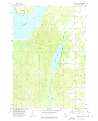
1972 Map of Beaver Lake
USGS Topo · Published 1975About this map
The waters of Fletcher Pond and Beaver Lake dominate this Northern Michigan landscape in Ossineke township during the early 1970s. The map illustrates a transitional rural economy where timber harvesting and early tourism began to overlap. An Old RR Grade running near the northern lakeshore serves as a tangible trace of the region's logging heritage, while Spring Park and the Public Access points at Emils Landing Rd reflect the growing recreational use of the water.
Find a feature on this map
28 named features on this map. Tap any name to fly to it.
Don’t see what you’re looking for? This feature index may not catch every label — zoom into the map to look around manually.
Map Details
Editions of this 1972 Beaver Lake Map
This is the sole edition of this map. No revisions or reprints were ever made.
Other maps of this area

1954 · Tawas City
USGS Topo · 1:250,000

1954 · Alpena
USGS Topo · 1:250,000

1955 · Hillman
USGS Topo · 1:62,500

1957 · Alpena
USGS Topo · 1:250,000

1958 · Alpena
USGS Topo · 1:250,000

1958 · Tawas City
USGS Topo · 1:250,000

1969 · Alpena
USGS Topo · 1:250,000

1971 · Lachine
USGS Topo · 1:24,000

1972 · McCollum Lake
USGS Topo · 1:24,000

1972 · Hubbard Lake SW
USGS Topo · 1:24,000