
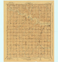
1910 Map of McComb
USGS Topo · Published 1910About this map
The Little River and its numerous tributaries, including Pecan Creek and Bullfrog Creek, define this 1910 landscape along the border of Cleveland and Pottawatomie counties. Surveyed shortly after Oklahoma statehood, the map reveals a dense network of early rural social centers, particularly schools like Solomons Temple School, Wildcat School, and Science Hill School. These landmarks, often established just miles apart, illustrate the settlement patterns of a period when proximity was essential for rural families.
Find a feature on this map
71 named features on this map. Tap any name to fly to it.
Don’t see what you’re looking for? This feature index may not catch every label — zoom into the map to look around manually.
Map Details
Editions of this 1910 McComb Map
2 editions found
Other maps of this area

1892 · Moore
USGS Topo · 1:62,500

1893 · Norman
USGS Topo · 1:62,500

1896 · Seminole and Prague
USGS Topo · 1:125,000

1898 · Purcell
USGS Topo · 1:125,000

1898 · Pauls Valley
USGS Topo · 1:125,000

1901 · Stonewall
USGS Topo · 1:125,000

1902 · Pauls Valley
USGS Topo · 1:125,000

1907 · Maud
USGS Topo · 1:62,500

1908 · Maud
USGS Topo · 1:62,500

1909 · Shawnee
USGS Topo · 1:62,500