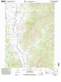
2001 Map of Mcconaughy Gulch
USGS Topo · Published 2004About this map
The Scott River valley dominates this Northern California landscape, where agricultural infrastructure and rugged terrain meet. Numerous wells, Storage Bins, and an Aqueduct illustrate the managed water system supporting the valley floor, contrasted by the steep drainage networks of Mcconaughy Gulch and Indian Gulch to the east. Of particular interest to genealogists and local historians is the Grave site near the river and a Cem located in the southern portion of the quadrangle. The map reflects a mix of modern communication and traditional resource extraction, shown by the Denny Point Communication Facility and several Prospects and a Gravel Pit. Notable landmarks like Duzel Rock and Hughes Hill provide orientation across a territory marked by numerous named springs and seasonal creeks such as French Creek and Etna Creek, which feed into the primary river system.
Find a feature on this map
29 named features on this map. Tap any name to fly to it.
Don’t see what you’re looking for? This feature index may not catch every label — zoom into the map to look around manually.
Map Details
Editions of this 2001 Mcconaughy Gulch Map
This is the sole edition of this map. No revisions or reprints were ever made.
Other maps of this area

1886 · Shasta
USGS Topo · 1:250,000

1894 · Shasta
USGS Topo · 1:250,000

1923 · Sawyers Bar
USGS Topo · 1:125,000

1931 · Etna
USGS Topo · 1:96,000

1932 · Yreka
USGS Topo · 1:96,000

1934 · Etna
USGS Topo · 1:125,000

1939 · Yreka
USGS Topo · 1:125,000

1948 · Weed
USGS Topo · 1:250,000

1950 · Weed
USGS Topo · 1:250,000

1954 · Yreka
USGS Topo · 1:62,500