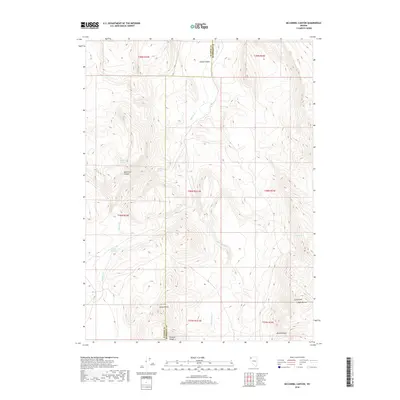
2018 Map of McConnel Canyon
USGS Topo · Published 2018About this map
The high desert terrain of the Nevada borderlands is documented in this 2018 survey, focusing on the remote corners where the Division Range and the Calico Hills meet. The landscape is defined by its scarce water sources, marked by essential landmarks such as Mcconnel Spring, Whiskey Spring, and Flower Spring. These watering holes served as critical points for movement through the arid basin and range territory. The topography is anchored by prominent elevations including Sheep Peaks and Sheep Buttes, which overlook the seasonal drainage of Little Smoky Cr. Evidence of water management in this dry environment is seen at the Willow Cr Reservoir, situated along the course of Willow Cr. Spanning the administrative boundary of Washoe and Humboldt Counties, the map illustrates a rugged geography shaped by canyons such as Mcconnel Canyon and Black Canyon.
Find a feature on this map
22 named features on this map. Tap any name to fly to it.
Don’t see what you’re looking for? This feature index may not catch every label — zoom into the map to look around manually.
Map Details
Editions of this 2018 McConnel Canyon Map
This is the sole edition of this map. No revisions or reprints were ever made.
Other maps of this area

1889 · Long Valley
USGS Topo · 1:250,000

1954 · Vya
USGS Topo · 1:250,000

1958 · Vya
USGS Topo · 1:250,000

1962 · Vya
USGS Topo · 1:250,000

1972 · Mud Meadow
USGS Topo · 1:24,000

1972 · Mahogany Mtn
USGS Topo · 1:24,000

1972 · High Rock Lake
USGS Topo · 1:24,000

1979 · Butte Spring
USGS Topo · 1:24,000
1980 · Leadville
USGS Topo · 1:24,000
1980 · Division Peak
USGS Topo · 1:24,000