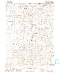
1991 Map of McConnell Peak
USGS Topo · Published 1991About this map
The Fort Mc Dermitt Indian Reservation spans the northern landscape of this Nevada-Oregon border region, where the high desert meets the rising elevations of the Santa Rosa Range. This 1991 provisional survey documents a rugged transition where the Quinn River and its various forks, including the South Fork and East Fork, navigate the arid terrain. Traces of the region's 19th-century history are evident in the Old Military Road, which cuts across the northwestern portion of the sheet near Minerva Peak.
Find a feature on this map
26 named features on this map. Tap any name to fly to it.
Don’t see what you’re looking for? This feature index may not catch every label — zoom into the map to look around manually.
Map Details
Editions of this 1991 McConnell Peak Map
This is the sole edition of this map. No revisions or reprints were ever made.
Other maps of this area

1882 · Paradise
USGS Topo · 1:250,000

1893 · Paradise
USGS Topo · 1:250,000

1955 · McDermitt
USGS Topo · 1:250,000

1955 · Jordan Valley
USGS Topo · 1:250,000

1957 · Jordan Valley
USGS Topo · 1:250,000

1958 · Jordan Valley
USGS Topo · 1:250,000

1959 · McDermitt
USGS Topo · 1:250,000

1959 · McDermitt
USGS Topo · 1:62,500

1980 · Odell Mountain
USGS Topo · 1:24,000
1980 · Holloway Meadows
USGS Topo · 1:24,000