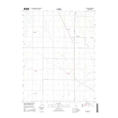
2014 Map of McCornick
USGS Topo · Published 2014About this map
McCornick serves as the primary point of settlement in this arid reach of Millard County, where the grid-based irrigation of the Central Utah Canal dictates the pattern of human habitation. The landscape is defined by the contrast between these engineered waterways and natural features like Whisky Cr and the seasonal flow of Eightmile Cr. A legacy of desert transit is visible in named routes such as Sheep Trail Rd and Foothill Blvd, which skirt the edges of the terrain while localized agriculture clusters around W Church Farm Rd. Further west, the ground rises toward the feature known as Knobby, with water sources like Antelope Spring and Mud Lake Spring providing vital landmarks in an otherwise sparse environment.
Find a feature on this map
22 named features on this map. Tap any name to fly to it.
Don’t see what you’re looking for? This feature index may not catch every label — zoom into the map to look around manually.
Map Details
Editions of this 2014 McCornick Map
This is the sole edition of this map. No revisions or reprints were ever made.
Other maps of this area

1885 · Sevier Desert
USGS Topo · 1:250,000

1951 · Oak City
USGS Topo · 1:62,500

1953 · Delta
USGS Topo · 1:250,000

1958 · Delta
USGS Topo · 1:250,000

1962 · Delta
USGS Topo · 1:250,000
1962 · The Sink
USGS Topo · 1:24,000
1962 · Holden
USGS Topo · 1:24,000

1962 · Holden
USGS Topo · 1:62,500

1962 · Delta
USGS Topo · 1:62,500

1971 · Pavant Butte North
USGS Topo · 1:24,000