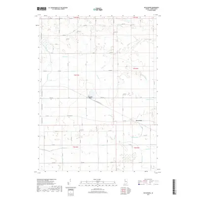
2019 Map of McCoysburg
USGS Topo · Published 2019About this map
Pleasant Ridge and McCoysburg anchor this rural landscape in Jasper County, where the transition from natural waterways to an engineered drainage system is clearly visible. The Iroquois River and Slough Creek are joined by an extensive network of man-made channels such as Moore Ditch, Ryan Ditch, and Sage Ditch, reflecting a long history of agricultural land reclamation. For those researching local families, the map is a significant resource, documenting several small burial grounds scattered across the townships, including Smith Cem, Hankle Cem, and Parkison Cem. The rigid grid of county roads, such as Co RD 550 and S Meridian Rd, structures the territory, while the southern portion of the quadrangle shows the winding path of Slough Creek as it moves toward the western boundary.
Find a feature on this map
64 named features on this map. Tap any name to fly to it.
Don’t see what you’re looking for? This feature index may not catch every label — zoom into the map to look around manually.
Map Details
Editions of this 2019 McCoysburg Map
This is the sole edition of this map. No revisions or reprints were ever made.
Other maps of this area

1953 · Chicago
USGS Topo · 1:250,000

1953 · Danville
USGS Topo · 1:250,000

1955 · Danville
USGS Topo · 1:250,000

1956 · Danville
USGS Topo · 1:250,000

1957 · Chicago
USGS Topo · 1:250,000

1962 · Monon
USGS Topo · 1:24,000

1962 · Medaryville
USGS Topo · 1:24,000

1962 · Gifford
USGS Topo · 1:24,000

1962 · Parr
USGS Topo · 1:24,000
1962 · Francesville
USGS Topo · 1:24,000