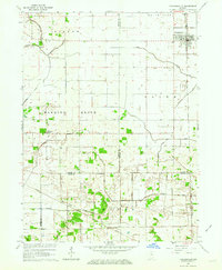
1962 Map of Francesville
USGS Topo · Published 1964About this map
Francesville anchors the northeastern corner of this 1960s landscape, where the Monon railroad corridor cuts a straight line through the agricultural heart of Pulaski and Jasper Counties. The map reveals an intensive system of water management, defined by a dense grid of drainage features including Pelsey Ditch, Barkley Ditch, and Ryan Ditch. This network allowed for the cultivation of the surrounding townships, such as Gillam and Hanging Grove, which were once dominated by the natural wet prairies of the Kankakee region.
Find a feature on this map
29 named features on this map. Tap any name to fly to it.
Don’t see what you’re looking for? This feature index may not catch every label — zoom into the map to look around manually.
Map Details
Editions of this 1962 Francesville Map
2 editions found
Other maps of this area

1953 · Chicago
USGS Topo · 1:250,000

1953 · Danville
USGS Topo · 1:250,000

1955 · Danville
USGS Topo · 1:250,000

1956 · Danville
USGS Topo · 1:250,000

1957 · Chicago
USGS Topo · 1:250,000

1962 · Monon NE
USGS Topo · 1:24,000

1962 · Monon
USGS Topo · 1:24,000

1962 · Monticello North
USGS Topo · 1:24,000

1962 · Medaryville
USGS Topo · 1:24,000

1962 · Gifford
USGS Topo · 1:24,000