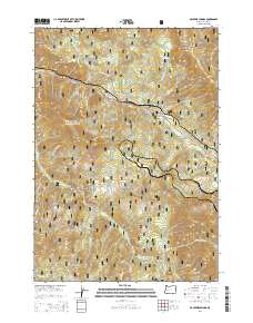
2014 Map of McCredie Springs
USGS Topo · Published 2014About this map
McCredie Springs and the nearby McCredie Hot Springs anchor this portion of the Willamette National Forest, where the corridor of Hwy 58 follows the winding path of Salt Creek. This modern survey illustrates the rugged high-elevation terrain of Lane County, characterized by a series of prominent peaks and ridgelines including Heckletooth Mtn, Monteith Rock, and Bunchgrass Ridge. The map documents a complex network of forestry roads, such as Nat Forest Develop Road 5877 Rd and Hills Creek Rd, which provide access to more secluded locations like Crabapple Prairie and Shady Gap. The drainage patterns are intricate, with numerous tributaries like Warner Cr, Fin Roberts Cr, and Mike Cr carving through the steep slopes of Cougar Mtn and Coyote Mtn.
Find a feature on this map
47 named features on this map. Tap any name to fly to it.
Don’t see what you’re looking for? This feature index may not catch every label — zoom into the map to look around manually.
Map Details
Editions of this 2014 McCredie Springs Map
This is the sole edition of this map. No revisions or reprints were ever made.
Other maps of this area

1925 · Waldo Lake
USGS Topo · 1:125,000

1955 · Chucksney Mtn
USGS Topo · 1:62,500

1956 · Waldo Lake
USGS Topo · 1:62,500

1956 · Oakridge
USGS Topo · 1:62,500

1956 · Sardine Butte
USGS Topo · 1:62,500

1958 · Roseburg
USGS Topo · 1:250,000

1959 · Roseburg
USGS Topo · 1:250,000

1983 · Oakridge
USGS Topo · 1:100,000
1986 · Groundhog Mountain
USGS Topo · 1:24,000
1986 · Warner Mountain
USGS Topo · 1:24,000