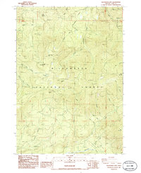
1986 Map of Groundhog Mountain
USGS Topo · Published 1986About this map
Willamette National Forest encompasses this high-altitude landscape in Lane County, dominated by the peaks of Buck Mountain, Groundhog Mtn, and Moss Mountain. The 1980s terrain is marked by a complex network of 4WD roads and industrial resource extraction sites, including numerous Quarries, Borrow Pits, and Gravel Pits scattered across the ridges. This network reflects a period of intensive forest management and infrastructure development within the Cascade Range. Water systems are prominent, with Groundhog Creek and its many tributaries, such as Noisy Creek and Coffeepot Creek, feeding into the Middle Fork Willamette River at the southern edge. The map also identifies recreational and natural landmarks like Waterdog Lake, Joes Prairie, and a designated Picnic Area near Logger Butte, providing a detailed look at how the forest was utilized for both industry and leisure during the late 20th century.
Find a feature on this map
42 named features on this map. Tap any name to fly to it.
Don’t see what you’re looking for? This feature index may not catch every label — zoom into the map to look around manually.
Map Details
Editions of this 1986 Groundhog Mountain Map
This is the sole edition of this map. No revisions or reprints were ever made.
Other maps of this area

1917 · Diamond Lake
USGS Topo · 1:125,000

1925 · Waldo Lake
USGS Topo · 1:125,000

1956 · Toketee Falls
USGS Topo · 1:62,500

1956 · Waldo Lake
USGS Topo · 1:62,500

1956 · Summit Lake
USGS Topo · 1:62,500

1956 · Oakridge
USGS Topo · 1:62,500

1958 · Roseburg
USGS Topo · 1:250,000

1959 · Roseburg
USGS Topo · 1:250,000

1978 · Diamond Lake
USGS Topo · 1:100,000

1983 · Oakridge
USGS Topo · 1:100,000