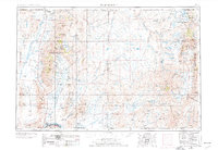
1955 Map of McDermitt
USGS Topo · Published 1977About this map
Mining operations and high-desert rangelands dominate this mid-century look at the borderlands where Nevada meets Oregon and Idaho. The landscape is defined by the heavy presence of extractive industry, including the Cordero Mine near the northern border and the Getchell Mine situated along the eastern flank of the Osgood Mountains. Settlements like McDermitt and the mining center of Tuscarora serve as hubs in a region shaped by the Humboldt National Forest and the vast Duck Valley Indian Reservation.
Find a feature on this map
93 named features on this map. Tap any name to fly to it.
Don’t see what you’re looking for? This feature index may not catch every label — zoom into the map to look around manually.
Map Details
Editions of this 1955 McDermitt Map
3 editions found

Other maps of this area

1882 · Paradise
USGS Topo · 1:250,000

1886 · Disaster
USGS Topo · 1:250,000

1893 · Paradise
USGS Topo · 1:250,000

1893 · Disaster
USGS Topo · 1:250,000

1931 · Lovelock
USGS Topo · 1:250,000

1932 · Sonoma Range
USGS Topo · 1:250,000

1935 · Lovelock
USGS Topo · 1:250,000

1936 · Mountain City
USGS Topo · 1:62,500

1939 · Sonoma Range
USGS Topo · 1:250,000

1939 · Owyhee
USGS Topo · 1:62,500