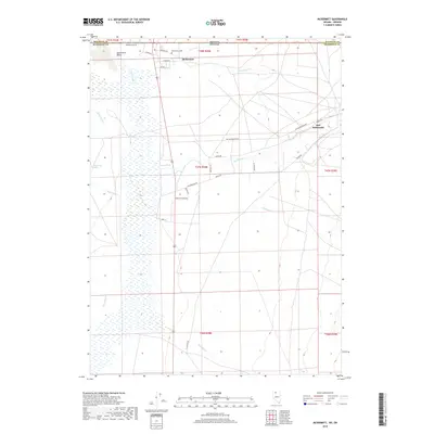
2018 Map of McDermitt
USGS Topo · Published 2018About this map
The border community of McDermitt sits at the northern edge of the Quinn River Valley, where the Nevada and Oregon state lines meet. This landscape is defined by the complex hydrology of the high desert, featuring the branching Quinn River and a network of seasonal drainages including Saint Martin Cr, Washburn Cr, and Twomile Cr. To the east lies Fort McDermitt, connected to the main settlement by Old Reservation Rd.
Find a feature on this map
38 named features on this map. Tap any name to fly to it.
Don’t see what you’re looking for? This feature index may not catch every label — zoom into the map to look around manually.
Map Details
Editions of this 2018 McDermitt Map
This is the sole edition of this map. No revisions or reprints were ever made.
Other maps of this area

1882 · Paradise
USGS Topo · 1:250,000

1893 · Paradise
USGS Topo · 1:250,000

1955 · McDermitt
USGS Topo · 1:250,000

1955 · Jordan Valley
USGS Topo · 1:250,000

1957 · Jordan Valley
USGS Topo · 1:250,000

1958 · Jordan Valley
USGS Topo · 1:250,000

1959 · McDermitt
USGS Topo · 1:250,000

1959 · McDermitt
USGS Topo · 1:62,500

1959 · Jordan Meadow
USGS Topo · 1:62,500
1982 · Tenmile Ranch
USGS Topo · 1:24,000