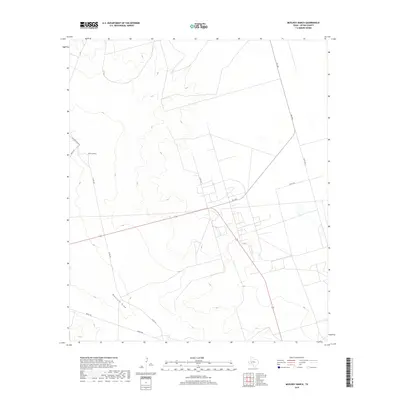
2019 Map of McElroy Ranch
USGS Topo · Published 2019About this map
McElroy Ranch serves as the namesake and primary hub of this Upton County landscape, situated amidst the high plains of West Texas. The terrain is defined by the subtle drainage patterns of Mayfield Draw, which winds through the southern portion of the quadrangle. A network of rural transportation, including FM 1492 and the appropriately named McElroy Ranch Rd, facilitates movement across this open ranching country. The geometric grid of county roads, such as Co Rd 305 and Co Rd 303, underscores the systematic division of land in this region, which remains largely dedicated to large-scale livestock operations and energy infrastructure as seen in the late 2010s.
Find a feature on this map
10 named features on this map. Tap any name to fly to it.
Don’t see what you’re looking for? This feature index may not catch every label — zoom into the map to look around manually.
Map Details
Editions of this 2019 McElroy Ranch Map
This is the sole edition of this map. No revisions or reprints were ever made.
Other maps of this area

1928 · Crane
USGS Topo · 1:125,000

1954 · Pecos
USGS Topo · 1:250,000

1957 · Pecos
USGS Topo · 1:250,000

1964 · Perkins Lake
USGS Topo · 1:24,000

1968 · Benge Corner SE
USGS Topo · 1:24,000

1968 · Benge Corner SW
USGS Topo · 1:24,000
1971 · Hanks Ranch
USGS Topo · 1:24,000

1971 · McElroy Ranch
USGS Topo · 1:24,000
1971 · Marlboro Canyon SE
USGS Topo · 1:24,000

1971 · Marlboro Canyon
USGS Topo · 1:24,000