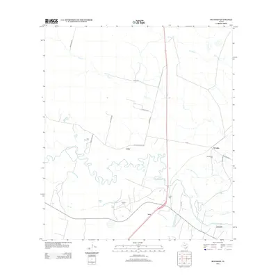
2013 Map of McFaddin
USGS Topo · Published 2013About this map
The San Antonio River meanders sharply across this South Texas landscape, defining a network of wetlands and abandoned channels including Old River and Cushman Bayou. The settlement of McFaddin serves as a primary hub in an area characterized by extensive petroleum extraction, with the Anaqua Oil Field, McFaddin Oil Field, and Huff Oil Field marking the industrial footprint on the land. Local history and genealogy are preserved in several family-named burial sites, such as the De la Garza Cem and the O'Connor Cem, which alongside the Nicholas Fagan Memorial Cem near the river, trace the region's ranching and settlement lineage. The road network, including Morris Town Rd and De La Garza Rd, connects these remote outposts and the small community of Inari through the brush country and river bottoms.
Find a feature on this map
26 named features on this map. Tap any name to fly to it.
Don’t see what you’re looking for? This feature index may not catch every label — zoom into the map to look around manually.
Map Details
Editions of this 2013 McFaddin Map
This is the sole edition of this map. No revisions or reprints were ever made.
Other maps of this area
1951 · Bloomington
USGS Topo · 1:24,000
1952 · Tivoli
USGS Topo · 1:24,000
1952 · Bloomington SW
USGS Topo · 1:24,000

1953 · Beeville
USGS Topo · 1:250,000
1954 · Vidaurri
USGS Topo · 1:62,500

1956 · Beeville
USGS Topo · 1:250,000

1960 · Beeville
USGS Topo · 1:250,000
1962 · Fannin
USGS Topo · 1:24,000
1962 · Lott Lake
USGS Topo · 1:24,000
1962 · McFaddin
USGS Topo · 1:24,000