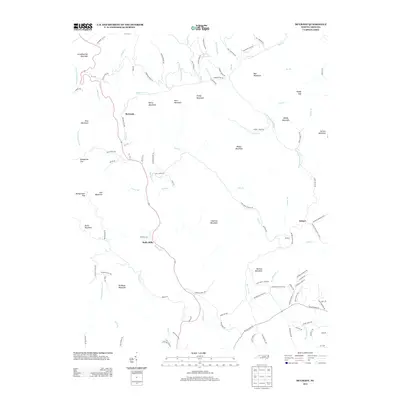
2013 Map of McGrady
USGS Topo · Published 2013About this map
Halls Mills and McGrady anchor this mountainous landscape where the upper reaches of the Mulberry Cr and W Prong Roaring River carve through a series of named peaks. The terrain is defined by its distinct high points, including Bullhead Mountain, Widow Mountain, and Grandmother Mountain. This area of Wilkes County is characterized by winding mountain roads like Longbottom Rd and Mulberry Gap Rd that follow the natural contours of the ridges and valleys. Small settlements like Radical and Dehart sit among the network of creeks such as Joshua Cr and Halls Cr. The presence of features like the Turkey Cove Pond and numerous gaps, including Bumgarner Gap, illustrates the physical geography that dictated local travel and habitation patterns in this portion of the Blue Ridge foothills.
Find a feature on this map
116 named features on this map. Tap any name to fly to it.
Don’t see what you’re looking for? This feature index may not catch every label — zoom into the map to look around manually.
Map Details
Editions of this 2013 McGrady Map
This is the sole edition of this map. No revisions or reprints were ever made.
Other maps of this area

1889 · Wilkesboro
USGS Topo · 1:125,000

1891 · Wilkesboro
USGS Topo · 1:125,000

1953 · Winston-Salem
USGS Topo · 1:250,000

1955 · Winston-Salem
USGS Topo · 1:250,000

1962 · Winston-Salem
USGS Topo · 1:250,000

1966 · Roaring River
USGS Topo · 1:24,000

1966 · Wilkesboro
USGS Topo · 1:24,000
1966 · Purlear
USGS Topo · 1:24,000
1968 · Glade Valley
USGS Topo · 1:24,000
1968 · Laurel Springs
USGS Topo · 1:24,000