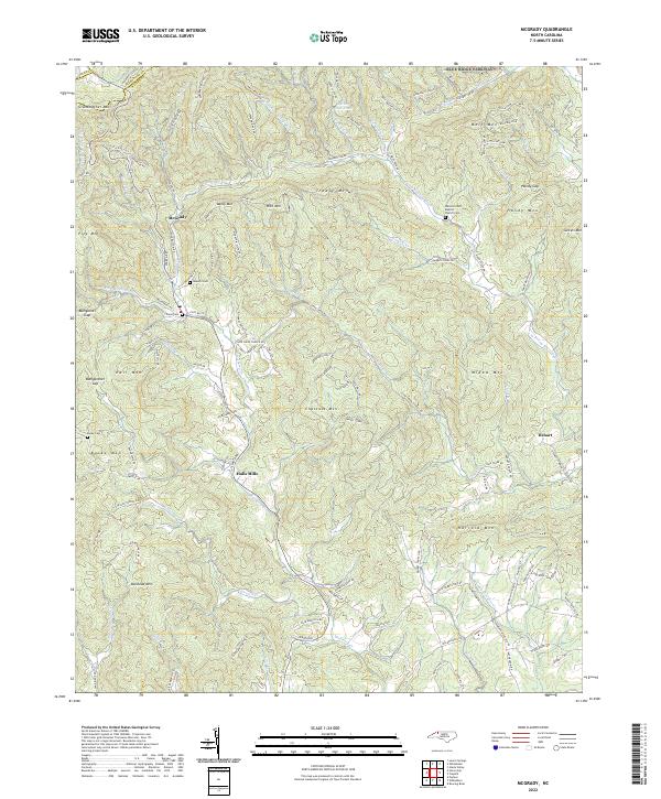
2022 Map of McGrady
USGS Topo · Published 2022About this map
McGrady and Halls Mills sit within the high-elevation drainages of northwestern Wilkes County, where the Blue Ridge Parkway skirts the northern boundary near the Alleghany and Ashe county lines. The landscape is defined by the steep descent of the W Prong Roaring River and Mulberry Cr, which carve through a series of named peaks including Grandmother Mtn, Rich Mtn, and Bullhead Mtn. Local family history is centered on several upland burial grounds and religious sites, such as the Walnut Grove Baptist Church Cem and the Ellis Mountain Cem. The road network, including the winding Sparta Rd and Longbottom Rd, reflects the difficulty of the terrain, connecting isolated valley settlements like Dehart to the larger community hubs. The presence of the Dehart Community Center and Cane Creek Church indicates the persisting social centers of these mountain enclaves.
Find a feature on this map
128 named features on this map. Tap any name to fly to it.
Don’t see what you’re looking for? This feature index may not catch every label — zoom into the map to look around manually.
Map Details
Editions of this 2022 McGrady Map
This is the sole edition of this map. No revisions or reprints were ever made.
Other maps of this area

1889 · Wilkesboro
USGS Topo · 1:125,000

1891 · Wilkesboro
USGS Topo · 1:125,000

1953 · Winston-Salem
USGS Topo · 1:250,000

1955 · Winston-Salem
USGS Topo · 1:250,000

1962 · Winston-Salem
USGS Topo · 1:250,000

1966 · Roaring River
USGS Topo · 1:24,000

1966 · Wilkesboro
USGS Topo · 1:24,000
1966 · Purlear
USGS Topo · 1:24,000
1968 · Glade Valley
USGS Topo · 1:24,000
1968 · Laurel Springs
USGS Topo · 1:24,000