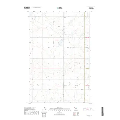
2020 Map of McGregor
USGS Topo · Published 2020About this map
McGregor sits at the heart of this North Dakota landscape, a hub in the prairie grid where 2nd Ave E and 81st St NW intersect. The map captures a quiet agrarian region at the meeting point of Williams, Burke, and Mountrail counties. This intersection of political boundaries is reflected in the dispersed placement of local heritage sites, particularly the numerous country cemeteries including Zion Cem, Saint Marys Cem, and Sharon Cem to the north, and Lindahl Lutheran Cem near Beauty Valley to the south.
Find a feature on this map
24 named features on this map. Tap any name to fly to it.
Don’t see what you’re looking for? This feature index may not catch every label — zoom into the map to look around manually.
Map Details
Editions of this 2020 McGregor Map
This is the sole edition of this map. No revisions or reprints were ever made.
Other maps of this area

1911 · Ray
USGS Topo · 1:125,000

1953 · Williston
USGS Topo · 1:250,000

1957 · Williston
USGS Topo · 1:250,000

1969 · White Earth
USGS Topo · 1:24,000

1974 · Hamlet
USGS Topo · 1:24,000

1974 · McGregor
USGS Topo · 1:24,000

1974 · Grand View
USGS Topo · 1:24,000
1974 · Bush Lake
USGS Topo · 1:24,000

1974 · Big Meadow
USGS Topo · 1:24,000

1978 · Battleview
USGS Topo · 1:24,000