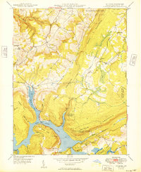
1949 Map of McHenry
USGS Topo · Published 1949About this map
Deep Creek Lake dominates the central and southern portions of this landscape, its complex shoreline defining the local geography with prominent features like Marsh Run Cove and Cherry Creek Cove. Located just after the war, the map reveals the area's transition into a recreational and conservation hub, anchored by the Thayer State Game Refuge and the Thayerville Lookout Tower. The settlement of McHenry sits at the northern tip of the lake, while the village of Thayerville occupies the southern narrows near Glendale Bridge.
Find a feature on this map
46 named features on this map. Tap any name to fly to it.
Don’t see what you’re looking for? This feature index may not catch every label — zoom into the map to look around manually.
Map Details
Editions of this 1949 McHenry Map
This is the sole edition of this map. No revisions or reprints were ever made.
Other maps of this area

1895 · Piedmont
USGS Topo · 1:125,000

1899 · Grantsville
USGS Topo · 1:62,500

1899 · Oakland
USGS Topo · 1:62,500

1900 · Accident
USGS Topo · 1:62,500

1900 · Oakland
USGS Topo · 1:62,500

1904 · Grantsville
USGS Topo · 1:62,500

1919 · Elk Garden
USGS Topo · 1:48,000

1920 · Elk Garden
USGS Topo · 1:48,000

1922 · Elk Garden
USGS Topo · 1:62,500

1946 · Grantsville
USGS Topo · 1:24,000