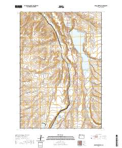
2020 Map of McKay Reservoir
USGS Topo · Published 2020About this map
Pilot Rock and the surrounding agricultural landscape of Umatilla County are defined by a network of creeks and drainage basins. The McKay Reservoir serves as a central hydrological feature, fed and flanked by numerous named watercourses including McKay Cr, Birch Cr, and Tutulla Cr. The terrain shifts from the low-lying reservoir area to the elevated Stewart Bench and through carved features like George Canyon and Spring Hollow. For local historians and genealogists, the map identifies specific points of local heritage such as Skyview Memorial Park and the McKay Creek Cem. A dense grid of county and local roads, such as Sparks Station Rd and Old Hwy 395, connects these rural homesteads and settlements, illustrating the 21st-century infrastructure of this eastern Oregon farming and ranching region.
Find a feature on this map
49 named features on this map. Tap any name to fly to it.
Don’t see what you’re looking for? This feature index may not catch every label — zoom into the map to look around manually.
Map Details
Editions of this 2020 McKay Reservoir Map
This is the sole edition of this map. No revisions or reprints were ever made.
Other maps of this area

1935 · Pendleton
USGS Topo · 1:125,000

1953 · Pendleton
USGS Topo · 1:250,000

1956 · Pendleton
USGS Topo · 1:250,000

1966 · Mc Kay Reservoir
USGS Topo · 1:24,000

1966 · Table Rock
USGS Topo · 1:24,000

1966 · Pendleton
USGS Topo · 1:24,000

1966 · Mission
USGS Topo · 1:24,000
1966 · Barnhart
USGS Topo · 1:24,000
1966 · Coombs Canyon
USGS Topo · 1:24,000

1967 · Nye
USGS Topo · 1:24,000