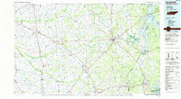
1986 Map of McKenzie
USGS Topo · Published 1986About this map
Kentucky Lake and the Tennessee River dominate the eastern reaches of this mid-1980s West Tennessee survey, where the Tennessee Valley Divide and Barren Divide separate distinct river basins. The landscape is a network of water and rail, with the Obion River and its multiple forks—North, Middle, South, and Rutherford Fork—draining the central and western lowlands toward the Mississippi. This era marks a significant point for regional conservation and infrastructure, shown through the sprawling Tennessee National Wildlife Refuge and the West Sandy Wildlife Management Area. Major transportation corridors like the Seaboard System RR and Illinois Central Gulf RR connect established trade centers such as Paris, McKenzie, and Martin, reflecting a well-developed agricultural and transit economy just before the turn of the 21st century.
Find a feature on this map
172 named features on this map. Tap any name to fly to it.
Don’t see what you’re looking for? This feature index may not catch every label — zoom into the map to look around manually.
Map Details
Editions of this 1986 McKenzie Map
3 editions found
Other maps of this area

1936 · Poplar Creek
USGS Topo · 1:24,000

1936 · Conyersville
USGS Topo · 1:24,000

1936 · Buchanan
USGS Topo · 1:24,000

1936 · Hazel
USGS Topo · 1:24,000

1936 · Tharpe
USGS Topo · 1:24,000

1936 · New Concord
USGS Topo · 1:24,000

1936 · Crossland
USGS Topo · 1:24,000

1936 · McKinnon
USGS Topo · 1:24,000

1936 · Camden
USGS Topo · 1:24,000

1936 · Seventeen Creek
USGS Topo · 1:24,000