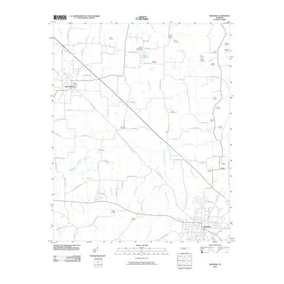
2010 Map of McKenzie
USGS Topo · Published 2010About this map
McKenzie and Gleason anchor this West Tennessee landscape, where the agricultural grid is etched with dozens of family burial grounds and small creek systems. The terrain is defined by the drainage of the Middle Fork Obion Lake, managed by the Middle Fork Obion Dam Eleven. Throughout the region, genealogists will find numerous small resting places like the Old El Bethel Cemetery, Tyson Cemetery, and Everett Chapel Cemetery scattered near rural thoroughfares like Old State Hwy 22. The Gleason Post Office serves as a central landmark for the town of Gleason, while the surrounding countryside is divided by named waterways such as Tumbling Creek, Spring Creek, and Boaz Creek. This 2010 survey records the enduring footprint of rural Tennessee settlements, preserving the names of local landowners through roads like Janes Mill Rd and Cannon Store Rd.
Find a feature on this map
84 named features on this map. Tap any name to fly to it.
Don’t see what you’re looking for? This feature index may not catch every label — zoom into the map to look around manually.
Map Details
Editions of this 2010 McKenzie Map
This is the sole edition of this map. No revisions or reprints were ever made.
Other maps of this area

1950 · Osage
USGS Topo · 1:24,000

1952 · Dresden
USGS Topo · 1:24,000

1955 · Henry
USGS Topo · 1:24,000

1955 · Huntingdon
USGS Topo · 1:24,000

1956 · Dyersburg
USGS Topo · 1:250,000

1957 · Como
USGS Topo · 1:24,000

1966 · Trezevant West
USGS Topo · 1:24,000

1967 · Pillowville
USGS Topo · 1:24,000
1967 · Trezevant East
USGS Topo · 1:24,000
1967 · Mc Kenzie
USGS Topo · 1:24,000