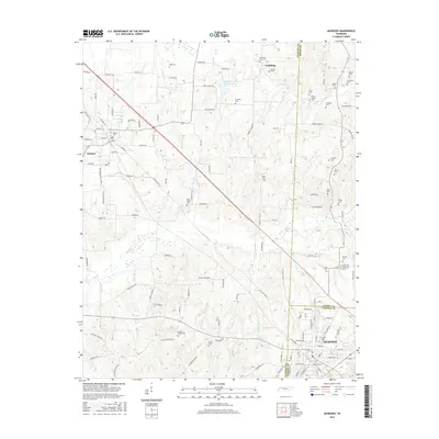
2016 Map of McKenzie
USGS Topo · Published 2016About this map
McKenzie and the neighboring community of Gleason anchor this Western Tennessee landscape, where the borders of Weakley, Henry, and Carroll counties converge. The area is defined by a dense network of family and community burial grounds, such as Smyth Cem and Page Cem, which offer significant value for genealogical research in this rural corridor. The northern reaches are shaped by the wetlands surrounding Middle Fork Obion Lake and the drainage of Tumbling Cr. This 2016 survey captures the established institutional presence of Bethel Coll alongside small rural congregations like Union Church and Everett Chapel Cem. The transition from the small-town street grids of McKenzie to the agricultural expanses connected by Old State Hwy 22 reveals a persistent pattern of rural settlement and local industry.
Find a feature on this map
130 named features on this map. Tap any name to fly to it.
Don’t see what you’re looking for? This feature index may not catch every label — zoom into the map to look around manually.
Map Details
Editions of this 2016 McKenzie Map
This is the sole edition of this map. No revisions or reprints were ever made.
Other maps of this area

1950 · Osage
USGS Topo · 1:24,000

1952 · Dresden
USGS Topo · 1:24,000

1955 · Henry
USGS Topo · 1:24,000

1955 · Huntingdon
USGS Topo · 1:24,000

1956 · Dyersburg
USGS Topo · 1:250,000

1957 · Como
USGS Topo · 1:24,000

1966 · Trezevant West
USGS Topo · 1:24,000

1967 · Pillowville
USGS Topo · 1:24,000
1967 · Trezevant East
USGS Topo · 1:24,000
1967 · Mc Kenzie
USGS Topo · 1:24,000