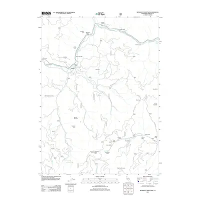
2012 Map of McKinley Mountain
USGS Topo · Published 2012About this map
The Klamath River carves a dominant path through this portion of Siskiyou County, defining the local geography around the settlement of Walker. The river corridor is marked by several named alluvial features such as Eagles Nest Bar and Round Bar, while the Walker Bridge provides a vital crossing point. North of the river, the landscape rises into steep gulches like Timber Gulch and Miller Gulch, while the southern reaches are dominated by significant peaks including McKinley Mountain and Deadwood Baldy Peak, the latter featuring the Deadwood Lookout.
Find a feature on this map
73 named features on this map. Tap any name to fly to it.
Don’t see what you’re looking for? This feature index may not catch every label — zoom into the map to look around manually.
Map Details
Editions of this 2012 McKinley Mountain Map
This is the sole edition of this map. No revisions or reprints were ever made.
Other maps of this area

1886 · Shasta
USGS Topo · 1:250,000

1894 · Shasta
USGS Topo · 1:250,000

1932 · Yreka
USGS Topo · 1:96,000

1939 · Yreka
USGS Topo · 1:125,000

1948 · Weed
USGS Topo · 1:250,000

1950 · Weed
USGS Topo · 1:250,000

1954 · Yreka
USGS Topo · 1:62,500

1955 · Condrey Mtn
USGS Topo · 1:62,500
1955 · Hornbrook
USGS Topo · 1:62,500
1955 · Fort Jones
USGS Topo · 1:62,500