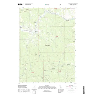
2018 Map of McKinley Mountain
USGS Topo · Published 2018About this map
The Klamath River carves through the heart of the Klamath National Forest in this survey of northern California. The settlement of Walker serves as a focal point along the river's path, connected by the Walker Bridge and surrounded by small riparian flats such as Eagles Nest Bar and Round Bar. This rugged portion of Siskiyou County is defined by its dramatic relief, where deep drainages like Lashes Gulch and Miller Gulch descend from high peaks including Deadwood Baldy Peak and McKinley Mtn. The map documents a network of forest roads and trails, such as the Little Grouse Tie and Barkhouse Loop, which provide access to the timbered slopes and remote coves. This modern record captures the enduring geography of the Klamath National Forest, highlighting the narrow balance between the river-level settlements and the surrounding high-altitude wilderness.
Find a feature on this map
56 named features on this map. Tap any name to fly to it.
Don’t see what you’re looking for? This feature index may not catch every label — zoom into the map to look around manually.
Map Details
Editions of this 2018 McKinley Mountain Map
This is the sole edition of this map. No revisions or reprints were ever made.
Other maps of this area

1886 · Shasta
USGS Topo · 1:250,000

1894 · Shasta
USGS Topo · 1:250,000

1932 · Yreka
USGS Topo · 1:96,000

1939 · Yreka
USGS Topo · 1:125,000

1948 · Weed
USGS Topo · 1:250,000

1950 · Weed
USGS Topo · 1:250,000

1954 · Yreka
USGS Topo · 1:62,500

1955 · Condrey Mtn
USGS Topo · 1:62,500
1955 · Hornbrook
USGS Topo · 1:62,500
1955 · Fort Jones
USGS Topo · 1:62,500