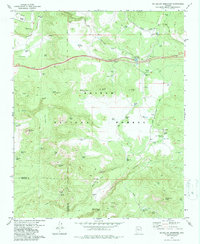
1979 Map of McLellan Reservoir
USGS Topo · Published 1979About this map
Kaibab National Forest dominates this northern Arizona landscape, where the high-altitude terrain is defined by volcanic features and a sophisticated network of water catchment systems. Johnson Crater and numerous cinder pits reflect the area's geological history, while the reliance on stored water is evident through dozens of named catchments, including McLellan Reservoir, Welsh Tank, and 13 Mile Tank. The Atchison Topeka and Santa Fe railroad skirts the northern edge of the map, running near an old railroad grade that points to earlier logging or transit corridors. Settlement is sparse, characterized by isolated holdings like Pine Springs Ranch and Quarter Circle XX Ranch, which are connected by primitive tracks and the Bill Williams Loop Road. Dramatic drop-offs into Hell Canyon and Devil Dog Canyon mark the southern reaches of the quadrangle.
Find a feature on this map
76 named features on this map. Tap any name to fly to it.
Don’t see what you’re looking for? This feature index may not catch every label — zoom into the map to look around manually.
Map Details
Editions of this 1979 McLellan Reservoir Map
4 editions found
Other maps of this area

1886 · Chino
USGS Topo · 1:250,000

1891 · Chino
USGS Topo · 1:250,000

1922 · Williams
USGS Topo · 1:125,000

1947 · Ash Fork
USGS Topo · 1:62,500

1948 · Ash Fork
USGS Topo · 1:63,360

1948 · Williams
USGS Topo · 1:250,000

1949 · Ash Fork
USGS Topo · 1:62,500

1954 · Williams
USGS Topo · 1:250,000

1956 · Williams
USGS Topo · 1:250,000

1960 · Williams
USGS Topo · 1:250,000