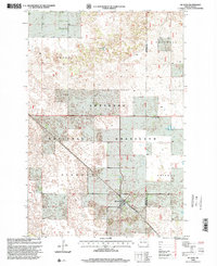
1998 Map of McLeod
USGS Topo · Published 2000About this map
Sheyenne National Grassland dominates this landscape on the border of Ransom and Richland counties, showing the protected prairie environment of southeastern North Dakota as it appeared in the late 1990s. The small community of McLeod serves as the primary hub of activity, situated along the diagonal tracks of the Soo Line railroad. This area is defined by its distinct townships, including Owego, Sheyenne, Sandoun, and Freeman, which organize the rural sections and grazing lands. For those tracing family history in the region, the Free Lutheran Cem stands as a notable landmark in the northern reaches of the quadrangle. The map reveals a high density of small wetlands and depressions characteristic of this glacial till plain, illustrating the complex drainage patterns that shape local land use and the boundaries of the national grassland.
Find a feature on this map
9 named features on this map. Tap any name to fly to it.
Don’t see what you’re looking for? This feature index may not catch every label — zoom into the map to look around manually.
Map Details
Editions of this 1998 McLeod Map
This is the sole edition of this map. No revisions or reprints were ever made.
Other maps of this area

1895 · Casselton
USGS Topo · 1:125,000

1897 · Casselton
USGS Topo · 1:125,000

1907 · Wyndmere
USGS Topo · 1:125,000

1953 · Fargo
USGS Topo · 1:250,000

1956 · Fargo
USGS Topo · 1:250,000

1960 · Wyndmere
USGS Topo · 1:24,000

1960 · Power
USGS Topo · 1:24,000

1960 · Wyndmere NW
USGS Topo · 1:24,000

1960 · Coburn
USGS Topo · 1:24,000

1960 · De Lamere
USGS Topo · 1:24,000