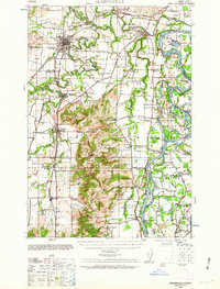
1940 Map of McMinnville
USGS Topo · Published 1963About this map
The Southern Pacific railroad and the Pacific Highway West converge near McMinnville and Lafayette, anchoring a landscape defined by the winding paths of the Yamhill River and Willamette River. This 1940 record of the northern Willamette Valley shows a dense network of rural infrastructure, from the Wheatland Ferry crossing the river at Wheatland to an array of named country schools like the evocatively named Grub College and Webfoot School.
Find a feature on this map
70 named features on this map. Tap any name to fly to it.
Don’t see what you’re looking for? This feature index may not catch every label — zoom into the map to look around manually.
Map Details
Editions of this 1940 McMinnville Map
3 editions found
Other maps of this area

1915 · Rickreall
USGS Topo · 1:31,680

1915 · Eola
USGS Topo · 1:31,680

1916 · Tualatin
USGS Topo · 1:62,500

1917 · Salem
USGS Topo · 1:62,500

1923 · Mount Angel
USGS Topo · 1:62,500

1924 · Mc Minnville
USGS Topo · 1:48,000

1925 · Stayton
USGS Topo · 1:62,500

1926 · Mc Minnville
USGS Topo · 1:62,500

1939 · Tualatin
USGS Topo · 1:62,500

1940 · McMinnville
USGS Topo · 1:62,500